

Sections of the trail had a multitude of wildflowersCapture Date: Aug 7, 2007 07:19 PM•Views: 104No comments yet. All fields are required, fill in the form. Comment successfully added. Comment
|
View up the North Fork
My first challenge was to surmount, via easy switchbacks, the cascades below First Lake. I started hiking about 5:30 p.m., and I wanted to reach my intended campsite - a cleared spot in the pines, not far below treeline - before dark. I kept a steady pace, without stopping - except for photographs - and made camp just as darkness fell.
Capture Date: Aug 7, 2007 06:06 PM•Views: 104
No comments yet. All fields are required, fill in the form. Comment successfully added. Comment
|
View up the South Fork of Big Pine Creek
Several peaks of Palisade reagion lie this way, including Middle Palisade and Norman Clyde Peak, which I visited about three decades ago. Maybe it's time to go back. This trip, the trail would take me up the north fork of Big Pine Creek.
Capture Date: Aug 7, 2007 05:46 PM•Views: 104
No comments yet. All fields are required, fill in the form. Comment successfully added. Comment
|
Now Playing: When Youre Falling by Peter Gabriel
Perhaps not the best choice of songs for a mountaineering trip.
Capture Date: Aug 7, 2007 07:42 PM•Views: 104
No comments yet. All fields are required, fill in the form. Comment successfully added. Comment
|
Water was easy to find on the lower slopes
I didn't bother with water purifiers or iodine tablets. Probably not a good idea, but it meant less weight, and more time to focus on gaining altitude.
Capture Date: Aug 9, 2007 07:53 AM•Views: 104
No comments yet. All fields are required, fill in the form. Comment successfully added. Comment
|
I didnt bother with cooking gear
I traveled light - no stove, no cup, mostly energy foods.
Capture Date: Aug 9, 2007 07:26 AM•Views: 104
No comments yet. All fields are required, fill in the form. Comment successfully added. Comment
|
At the start of the journey
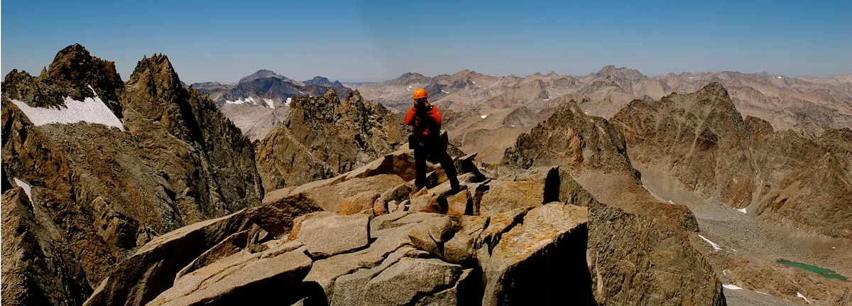
What would it feel like to reach the summit of a 14,000 foot peak at my age (pushing 60)? Having tried the to reach the summit the previous week (and having failed because I didn't have the right equipment), I knew I was in shape. Yet there were other challenges ahead, beyond the need for endurance and the ability to use an ice axe and crampons. I hadn't used my soft hands to climb hard granite in many years, and I'd have to deal with some serious exposure near the top of the mountain.
Capture Date: Aug 7, 2007 05:31 PM•Views: 105
No comments yet. All fields are required, fill in the form. Comment successfully added. Comment
|
I have not changed much since 1975 - have I?Views: 109No comments yet. All fields are required, fill in the form. Comment successfully added. Comment
|
View of the Palisades Region from Glacier Lodge
The trail head for the high country begins at Glacier Lodge, elevation a little under 8,000 feet, where there are cabins, a campground, a little store, and a place to park a car.
Capture Date: Aug 9, 2007 09:00 AM•Views: 106
No comments yet. All fields are required, fill in the form. Comment successfully added. Comment
|
Mt. Sill and the Sill Glacier
My route would lead up from the right, over the Palisade Glacier, hidden behind the peak sticking up in the foreground
Capture Date: Aug 9, 2007 09:34 AM•Views: 107
No comments yet. All fields are required, fill in the form. Comment successfully added. Comment
|
Mt. Sill From Highway 395
Mt. Sill viewed from the east, just outside the little town of Big Pine
Capture Date: Aug 9, 2007 09:32 AM•Views: 108
No comments yet. All fields are required, fill in the form. Comment successfully added. Comment
|


No comments yet...
All fields are required, fill in the form.
Comment successfully added.
Comment