

View up the L-Shaped Glacier
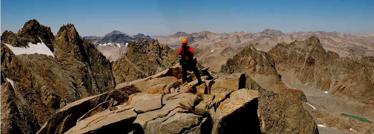
Mt. Sill, still several hundred feet above me, looms overhead. Some climbers scramble up the Class 3 boulder/rocks to the right; I kept my crampons on as long as possible and made my way straight up the quite steep ice. I'm not sure which would have been easier, the rocks or the ice, but I wasn't necessarily after an easy time. Capture Date: Aug 8, 2007 10:44 AM•Views: 98
It's difficult to get a sense of scale - the tongue of the glacier ascends for a few hundred feet. This was probably one of the more difficult parts of the climb, because it took some effort to put one foot in front of the other up the steep slope of the ice. And yet, despite my fears that my endurance, given my age, would be less than it was three decades ago, I felt good as I slowly kicked steps into the glacier and made my way toward the crux of the climb. No comments yet. All fields are required, fill in the form. Comment successfully added. Comment
|
At the base of the L-Shaped Glacier
Ice on the left, Mt. Gayley on the right.
Capture Date: Aug 8, 2007 10:36 AM•Views: 98
No comments yet. All fields are required, fill in the form. Comment successfully added. Comment
|
Moving up the Palisade GlacierCapture Date: Aug 8, 2007 09:37 AM•Views: 95No comments yet. All fields are required, fill in the form. Comment successfully added. Comment
|
SteepCapture Date: Aug 8, 2007 09:48 AM•Views: 101No comments yet. All fields are required, fill in the form. Comment successfully added. Comment
|
Yes, sharp!
The sharp points of the crampons insured that I would maintain traction on the ice of the glacier.
Capture Date: Aug 8, 2007 09:23 AM•Views: 101
No comments yet. All fields are required, fill in the form. Comment successfully added. Comment
|
The crampons expand!Capture Date: Aug 8, 2007 09:19 AM•Views: 94No comments yet. All fields are required, fill in the form. Comment successfully added. Comment
|
Lightweight crampons
After passing through a boulder field to reach the glacier, it was time to pull my lightweight "Kahtoola" crampons out of my pack.
Capture Date: Aug 8, 2007 09:18 AM•Views: 94
No comments yet. All fields are required, fill in the form. Comment successfully added. Comment
|
The Palisades
Another view of the Palisades (made on the previous week's failed attempt), including the Palisade Glacier, in the Sierra Nevada Mountains of California. Mount Sill is on the left.
Views: 95
No comments yet. All fields are required, fill in the form. Comment successfully added. Comment
|
Viewpoint of the Palisades Glacier, 12,500 feet above sea levelCapture Date: Aug 8, 2007 08:27 AM•Views: 94No comments yet. All fields are required, fill in the form. Comment successfully added. Comment
|
Last wildflowersCapture Date: Aug 8, 2007 08:02 AM•Views: 95No comments yet. All fields are required, fill in the form. Comment successfully added. Comment
|
A duck (marker made from rocks) shows the way up the morrainCapture Date: Aug 8, 2007 07:57 AM•Views: 94No comments yet. All fields are required, fill in the form. Comment successfully added. Comment
|
Mt Galey and its glacier viewed from the edge of a glacial morrainCapture Date: Aug 8, 2007 07:53 AM•Views: 96No comments yet. All fields are required, fill in the form. Comment successfully added. Comment
|
ColumbineCapture Date: Aug 8, 2007 07:43 AM•Views: 96No comments yet. All fields are required, fill in the form. Comment successfully added. Comment
|
View of Galey and Sill (the latter in the background)
Close to 12,000 feet, and the trail has petered out. The prime directive: reach the top of the rocky ridge.
Capture Date: Aug 8, 2007 07:40 AM•Views: 94
No comments yet. All fields are required, fill in the form. Comment successfully added. Comment
|
83646676.iknTRWcw.sillpbase2DSC_5737Capture Date: Aug 8, 2007 07:33 AM•Views: 95No comments yet. All fields are required, fill in the form. Comment successfully added. Comment
|

No comments yet...
All fields are required, fill in the form.
Comment successfully added.
Comment