Dave Wyman's Gallery
California Galleries
California My Way
December through March, 2005
https://davewyman.slickpic.com/albums/DecemberThroughMarch2005/photo/#3498155
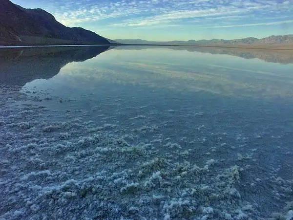
Shrimpers Clammers at Morro Bay use a long suction tube to hunt for clams, at sunset along the central coast of California. The sun is dropping behind the massive sand dunes that enclose the west side of the bay.
https://davewyman.slickpic.com/albums/DecemberThroughMarch2005/photo/#3498154
December 21, 2004 California condors are the largest flying animals in North America, with wingspans that can stretch to 10 feet and weights that tip the scale at 25 pounds. This condor zooms over a ridge in the remote Topatopa Mountains, northwest of Los Angeles. Notice the antennas on the wings that transmit data to biologists.
https://davewyman.slickpic.com/albums/DecemberThroughMarch2005/photo/#3498152
December 22, 2004 This is the view looking through the windshield of my car while sitting in heavy traffic, trying to come into Los Angeles from the north, on the Interstate Five freeway. (My hat is tipped to pbaser Phil Douglis for helping me see this picture.)
https://davewyman.slickpic.com/albums/DecemberThroughMarch2005/photo/#3498151
December 23, 2004 The view from my front yard, in the historic South Carthay neighborhood of Los Angeles
https://davewyman.slickpic.com/albums/DecemberThroughMarch2005/photo/#3498150
December 24, 2004 The Pala Mission
https://davewyman.slickpic.com/albums/DecemberThroughMarch2005/photo/#3498149
December 25, 2004 Snow in California
https://davewyman.slickpic.com/albums/DecemberThroughMarch2005/photo/#3498148
December 26, 2004 Orange Grove on the outskirts of the city of Redlands
https://davewyman.slickpic.com/albums/DecemberThroughMarch2005/photo/#3498147
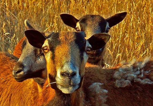
December 27, 2004 Goats near the ranching community of Parkfield, the "Earthquake Capitol of the World" in the Coast Range mountains.
https://davewyman.slickpic.com/albums/DecemberThroughMarch2005/photo/#3498146
December 28, 2004 More than 5,000 wind turbines crank out the power in and around Tehachapi Pass, in the mountains east of the city of Bakersfield.
https://davewyman.slickpic.com/albums/DecemberThroughMarch2005/photo/#3498145
December 29, 2004 The chairlift at the Mount Waterman. The ski area is in the San Gabriel Mountains, about an hour and a half north of Los Angeles.
https://davewyman.slickpic.com/albums/DecemberThroughMarch2005/photo/#3498144
December 30, 2004 Flowers - Hollywood Farmers Market
https://davewyman.slickpic.com/albums/DecemberThroughMarch2005/photo/#3498143
December 31, 2004 Photographed in rural Catheys Valley, west of Yosemite National Park, a few days before the end of the year.
https://davewyman.slickpic.com/albums/DecemberThroughMarch2005/photo/#3498142
January 1, 2005 This morning, January 1, 2005, I was in Yosemite National Park, walking through the fresh fallen snow in the Valley, enjoying the wonderful views of the granite walls and peaks that were occasionally revealed as the sun broke through the clouds. I am a very lucky person. May the world be more peaceful
https://davewyman.slickpic.com/albums/DecemberThroughMarch2005/photo/#3498141
January 2, 2005 North Dome, Yosemite National Park, viewed from Stoneman Meadow at the end of the day, at the end of 2004.
https://davewyman.slickpic.com/albums/DecemberThroughMarch2005/photo/#3498140
January 3, 2005 An oak sits in the twilight in Yosemite Valley
https://davewyman.slickpic.com/albums/DecemberThroughMarch2005/photo/#3498139
January 4, 2005 After a storm in Yosemite Valley, the temperature rose enough to melt some of the snow. A drop of water formed at the base of a pine needle.
https://davewyman.slickpic.com/albums/DecemberThroughMarch2005/photo/#3498138
January 5, 2005 Sisters take a break on the trail to the Freeman Grove, Sequoia National Monument
https://davewyman.slickpic.com/albums/DecemberThroughMarch2005/photo/#3498137
January 6, 2005 There are dozens of mansions in the city of Redlands, at the base of the San Bernardino Mountains of southern California. The mansions were built on the profits of the citrus industry that once reigned supreme in the southern half of the state. This is the Kimberly Crest House, the most eleaborate and probably the largest of all the mansions. The house is surrounded by a magnificent garden.
https://davewyman.slickpic.com/albums/DecemberThroughMarch2005/photo/#3498135
January 7, 2005 California Poppy Preserve, Antelope Valley, north of the La Liebre Mountains.
https://davewyman.slickpic.com/albums/DecemberThroughMarch2005/photo/#3498134
January 8, 2005 His First Catch - Sequoia National Monument
https://davewyman.slickpic.com/albums/DecemberThroughMarch2005/photo/#3498133
January 9, 2005 The beautiful Arc Bridge, on Highway 154, is in the Coast Range Mountains beyond Santa Barbara; Old Stage Coach Road is visible in the shadows. Without taking the old road, which gives a look back at the the canyon, it is impossible to see the bridge, particulary while driving over it.
https://davewyman.slickpic.com/albums/DecemberThroughMarch2005/photo/#3498132
January 10, 2005 A rattlesnake crosses the road in Carrizo Plain National Monument.
https://davewyman.slickpic.com/albums/DecemberThroughMarch2005/photo/#3498131
January 11, 2005 Train tracks in the late afternoon sun (and with some serious underexposure) near the famed Tehachapi Loop, in the mountains east of Bakersfield.
https://davewyman.slickpic.com/albums/DecemberThroughMarch2005/photo/#3498130
January 12, 2005 Road side shrine, near Buttonwillow, in the Central Valley of California. http://www.pbase.com/dazedgonebye/descansos
https://davewyman.slickpic.com/albums/DecemberThroughMarch2005/photo/#3498129
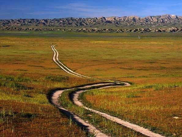
January 13, 2005 Carrizo Plain National Monument.
https://davewyman.slickpic.com/albums/DecemberThroughMarch2005/photo/#3498128
January 14, 2005 Only Texas and Alaska produce more oil than California. Most of the petroleum in California comes the southwestern portion of the San Joaquien Valley, where this picture was made, in the hilly oilfields above the city of Taft.
https://davewyman.slickpic.com/albums/DecemberThroughMarch2005/photo/#3498127
January 15, 2005 Malibu Creek State Park, in the Santa Monica Mountains, is 25 miles from downtown Los Angeles by car. There is a short walk from the parking area to the creek, and there are miles of hiking and mountain biking trails over four thousand acres of backcountry. The park features rugged gorges, volcanic cliffs, meadows, woodland, waterfalls, rock pools and a two-acre lake. The land was once owned and divided between Ronald Reagan, Bob Hope and the 20th Century Fox film studio. The park was the backdrop for many films and television shows, including Planet of the Apes and M.A.S.H.
https://davewyman.slickpic.com/albums/DecemberThroughMarch2005/photo/#3498126
January 16, 2005 Non-native artichoke, Yosemite Valley. "This year the park service is planning to eradicate bull thistle (Cirsium vulgare), mullein (Verbascum thapsus), the ice artichoke (Cynara humongus) and other invasive non-native plants that threaten priority areas of Yosemite Valley." - 2005 park service bulletin.
https://davewyman.slickpic.com/albums/DecemberThroughMarch2005/photo/#3498125
January 17, 2005 The Kelso Dunes are more than 600 feet tall. They can be found near the remote community of Kelso, once an important watering stop for locomotives along the rail line. The overcast day made the landscape and old highway look almost painterly.
https://davewyman.slickpic.com/albums/DecemberThroughMarch2005/photo/#3498124
January 18, 2005 Sheep on the remote Carrizo Plain. Broken hills in the background are evidence of the San Andreas earthquake fault, which runs from north of San Francisco south into Mexico.
https://davewyman.slickpic.com/albums/DecemberThroughMarch2005/photo/#3498123
January 19, 2005 Morning light, El Capitan, Yosemite
https://davewyman.slickpic.com/albums/DecemberThroughMarch2005/photo/#3498122
January 20, 2005 El Capitan, Yosemite
https://davewyman.slickpic.com/albums/DecemberThroughMarch2005/photo/#3498121
January 21, 2005 Bottle art - a kind of folk art - can be found in the Mojave Desert on historic Route 66. between the towns of Victorville and Barstow (where I am going next week to conduct a photo safari).
https://davewyman.slickpic.com/albums/DecemberThroughMarch2005/photo/#3498120
January 22, 2005 Curvy Santa Rosa Creek Road travels east from the little town of Cambria, on the central coast of California, high into the Coast Range Mountains. This view, near the crest of the road, looks back down the canyon on a rainy afternoon.
https://davewyman.slickpic.com/albums/DecemberThroughMarch2005/photo/#3498119
January 23, 2005 An oil well pumps away in the hills above the city of Taft.
https://davewyman.slickpic.com/albums/DecemberThroughMarch2005/photo/#3498117
January 25, 2005 Hopper Mountain Condor reserve, Topa Topa Mountains
https://davewyman.slickpic.com/albums/DecemberThroughMarch2005/photo/#3498116
January 26, 2005 The old Ridge Route, north of Los Angeles. It's still possible to make the drive on this historic road between the community of Castic and the Antelope Valley.
https://davewyman.slickpic.com/albums/DecemberThroughMarch2005/photo/#3498115
January 27, 2005 The sun is about to set over Highway 94 and the Campo Valley, near the California border with Mexico.
https://davewyman.slickpic.com/albums/DecemberThroughMarch2005/photo/#3498114
January 28, 2005 Hidden Falls, Mountain Home state forest, in the Sierra Nevada Mountains.
https://davewyman.slickpic.com/albums/DecemberThroughMarch2005/photo/#3498113
January 31, 2005 This old Chevy truck hasn't run in decades. It's in the desert, near the community of Amboy, California.
https://davewyman.slickpic.com/albums/DecemberThroughMarch2005/photo/#3498112
February 1, 2005 Abandoned houses at Amboy, California, along historic Route 66.
https://davewyman.slickpic.com/albums/DecemberThroughMarch2005/photo/#3498111
February 2, 2005 Beware the ersatz roof-mounted canon, in the desert town of Barstow, (along Old Highway 58).
https://davewyman.slickpic.com/albums/DecemberThroughMarch2005/photo/#3498110
February 3, 2005 All would seem still at the Daggett Pioneer Cemetery, but ants sty busy excavating their colony.
https://davewyman.slickpic.com/albums/DecemberThroughMarch2005/photo/#3498109
February 4, 2005 Cow and tractor at the Fiscallini farm, near Cambria, along the Central Coast of California.
https://davewyman.slickpic.com/albums/DecemberThroughMarch2005/photo/#3498108
February 5, 2005 Sunset at Cambria, along Moonstone Beach, along the Central Coast of California.
https://davewyman.slickpic.com/albums/DecemberThroughMarch2005/photo/#3498107
February 6, 2005 Yosemite Chapel
https://davewyman.slickpic.com/albums/DecemberThroughMarch2005/photo/#3498106
February 7, 2005 Tractor and stacked wine casks (the latter for sale!) near the ever-encroaching city of San Luis Obispo.
https://davewyman.slickpic.com/albums/DecemberThroughMarch2005/photo/#3498105
February 8, 2005 This is a picture of expansion tubes and a California quail at sunset, made near the little oil town of Maricopa. The expansion tubes help relieve potentially damaging uneven pressure in oil pipelines. A California quail, the state bird, sits atop the tubes.
https://davewyman.slickpic.com/albums/DecemberThroughMarch2005/photo/#3498104
February 9, 2005 Fern Spring - Smallest Waterfall in Yosemite
https://davewyman.slickpic.com/albums/DecemberThroughMarch2005/photo/#3498103
February 10, 2005 Wildflowers at the California state poppy preserve, in the Antelope Valley.
Scroll To Top
Audio Mute
Prev
Play
Next
Shuffle
Include
This site uses cookies to enhance your browsing experience, serve personalized content, and analyze traffic. By continuing to use this site you agree to
use of cookies and stewardship of your data .


No comments yet...
All fields are required, fill in the form.
Comment successfully added.
Comment